Since the the late 1800s to early 1900s, the origins of the native people located in the area of Robeson County North Carolina has been heatedly debated by individuals with no actual connection to the people of this land. Various identities were placed on these people by the state in an attempt to eliminate the political threats of their true identity, as well as to gain favoritism by creating a large voting block for their own political party. Over the period of years, various names have been thrown around in an attempt to appease the native people and to win over their support by means of bribing them, the state would offer particular benefits if they were to accept an identity over another and would hire “researchers” to manipulate their histories in an attempt to solidify their false claims.
Among the first of these identities was the Croaton.
The Croaton was given as a cover identity for all the native peoples of Sampson and Robeson Counties by Hamilton McMillan who was a Democratic politician of North Carolina. He was allegedly convinced that the people of these lands were descendants of the lost colony due to the oral stories taken from a few families. He provides no actual evidence that supports this claim, and I suspect he was using this as an attempt to further disenfranchise the people here as indigenous.
Although there may be some truth in the stories of the lost colony, however Croaton was not a tribe, but rather a location/settlement on the island of Hatteras/Katteras. And by February 12th 1885 it would appear that the natives of this land were well aware of that as indicated by this article published in the Fayetteville Observer where McMillan contradicts himself entirely.
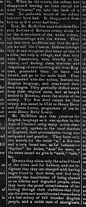
“They say that their traditions say that the people we call Croaton Indians, (Though they do not recognize that name as a tribe, but only a village, and that they are Tuscarora)”
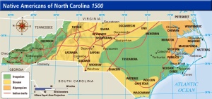
(Note that territory between the Tuscarora and Chowanoke in the eastern corner on the east side of the river was continuously exchanged before Chowanoke people were absorbed into Tuscarora. Further note this is a linguists map which although shows territories, it does no show confederacies territory as a whole, much of the eastern Algonquin people joined under the Tuscarora Confederacy, this will be important when we later further discuss the lost colony stories.)
Hamilton McMillan was not exactly the most righteous of individuals, and despite for some reason being held as a white savior in Robeson County, he cared very little of the native people there. Personal statements from his own daughter Cornelia, state that ‘Indians’ would have to use the backdoor of his house when they came to visit, she further stated that whenever in his presence, the Indians would have to stand, and in this she took great pride in.
Regardless of being slightly misleading, the name Croaton stuck with the state when identifying the native peoples of the region for years until about 1911 when the natives in the region were simply called ‘The Indians of Robeson County.’ This name however didn’t last long either, they were desperate for an identity change as many families were still clinging onto their Tuscarora identities, so by 1915 the state placed the name of the already established Cherokee onto the natives of Robeson county. Native theorist, Clifton Oxendine suggested that the people of Robeson county descend from the Cherokee warriors that joined Barnwell on his campaign to fight the Tuscarora, and that the warriors settled in the swamps with their Tuscarora captives…. Although he was claiming Cherokee, he was also acknowledging the Tuscarora blood. Note that by our tribal traditions between the Tuscarora and Cherokee, these people would have remained Tuscarora as they were never officially absorbed into the Cherokee nation, in fact these non-existing Cherokee warriors, which would have been comprised of men would be considered Tuscarora as they began to marry their female Tuscarora captives as we are both matrilenal societies.
Unfortunately for Mr. Oxendine, he overlooked the part where the Cherokee did NOT join Barnwell in his campaign against the Tuscarora. This can be seen in the reports made continuously throughout the war by Barnwell himself, which can be found at this address. https://archive.org/details/jstor-27575182
Why were names constantly being throw around among these people? And why by 1911-1915 were they so desperate choose a single identity that had no relation to the people who lived in the region?
The answers can be found in treaty rights. Many are unaware of the treaty lease of the Indian Woods Reservation of Bertie County where most Robeson/Sampson County families descend from… The lease was made by the Tuscarora for 150 years and it was to end by 1917. As stated on the treaty/lease, the land was supposed to revert back to any Tuscarora descendants that remained in the state of North Carolina. So in short, if you change their name, you change their identity, you create a loophole, thus you can deny them their treaty rights. These names were obviously not created in hopes for unity, but rather an attempt to divide our blood lines and to deny us our rights as an indigenous people of these lands.
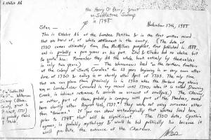
By the 1920s, the Siouan/Cheraw claims began to emerge due to the research of Swanton. It is misunderstood that his research indicated that all the people or a large majority of the people within Robeson county descend from the Cheraw. In reality Swanton stated, “SOME of their descendants are represneted among the Robeson County Indians, often miscalled the Croatans.” And this may be fact to some extent. So far the only families that can be traced to the Cheraw bloodline is the Grooms, and many researchers for the Lumbee agree.
As shown in this letter from White.
I personally believe there may be a connection with the Kerns family as well, however this is only due to rumor and I have not personally seen any evidence yet to prove this.
One thing people must keep in mind at this time is that these people were exhausted of the various name changes, and in the attempt to appease the government, they were willing to accept just about what ever name, or theory given to them which has created much of the confusion among families today.
There has been very little evidence to support this claim of Cheraw descent, rather only assumptions due to logistics… It should be noted that the Cheraw were absorbed into the Catawba, and that the Catawba officially deny the claims of Cheraw descent of the Lumbee.
Let me explain some of the evidence they do try to use for the argument of Cheraw.
The 1915 McPherson Report said in reference to the Cheraw (quoting the Handbook of American Indians, 1906):
“Their numbers in 1715, according to Rivers, was 510, but this estimate probably included the Keyauwee. Being still subject to attack by the Iroquois, they finally—between 1726 and 1739—became incorporated with the Catawba…. They are mentioned as with the Catawba but speaking their own distinct dialect as late as 1743 (Adair). The last notice of them in 1768, when their remnant, reduced by war and disease to 50 or 60, were still living with the Catawba.”[45]
I’m not entirely sure how this is used as evidence for the Cheraw claim, however this quote is often mentioned when ever it is debated… On the contrary, this quote indicates that the Cheraw were decimated and absorbed with the Catawba, and were NOT living in the area of Robeson County.
The other major claim of Cheraw descent is the alleged Cheraw Settlement of Drowning Creek.
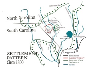
Their has only been a couple of mentioning of this settlement, none of which indicate it ever being in Robeson County, or it actually being Cheraw.
In 1771 however, the South Carolina Gazette mentioned the Cheraw settlement and known native outlaw, Winsler Driggers.
“a convicted felon by the name of Winsler Driggers was captured “near Drowning Creek, in the Charraw settlement”. (It should be noted that the Driggers native blood comes from the Edgecombe region around Indian Woods Tuscarora reservation, and the Driggers trace their ancestry to Tuscarora Indians)
So where exactly was this Cheraw settlement?
According to John Herberts map published in 1725, it indicates the Cheraw Settlement was at the time, 50 miles south west of what is now Robeson County. However it shows a Waccamaw settlement south east. (It should be noted that the Waccamaw were betrayed by their white allies after the Tuscarora war and a campaign to remove them from the southern North Carolina frontier pushed them on the side of South Carolina.)
By 1726, the Cheraw settlement and it’s people disappear on record as an individual group however appear as to be absorbed by the Catawba almost another 100 miles away west.
By 1753, North Carolina Governor Matthew Rowan proclaims Drowning Creek (now Lumber River) a “frontier to the Indians”, and states that there are “no Indians in the county.”
That same year
“Tuscarora Chief William “Billy” Pugh is issued land grant on Saddletree swamp in northern part of Robeson County. (Issued May 9, 1753, North Carolina
Land Grant, Bladen County, File #415, Book2.)
By this time, 50 families were noted along Drowning Creek, which is misleadingly used to confirm the Cheraw settlement. These 50 families were stated to be the Blount Indians, which were said to be white Indians as they had now lived in a similar manner to that of the Europeans. These families can be found on tax list alongside Chief Pugh and Chief Blount.
“1754
Governor Arthur Dobbs receives a report from a Bladen County agent of 50 Indian families living along Drowning Creek (present-day Lumber River). The communication also reports the shooting of a surveyor who entered the area “to view vacant lands.” It is the first written account of the tribe from whom the Lumbee descended.”
On 15 March, 1756, James Blunt (sic) was issued a warrant for 150 acres of land in Bladen County, NC at the
mouth of Black Swamp. The land was also described as on Back (sic) Swamp on the east side of Drownding (sic)
Creek including Buksle’s improvement.
“1757
Bertie County Tuscarora chieftain James Blount writes:
“We the Tuskarora Indians Petition Your Excely. and Council to Grant a Pattent, or Some Better Title for Our Land for the White folks tells this is good for nothing and they Come and Settle Without leave Sale our Timber and Drive Stocks of all sorts: We hope Care will be Taken to protect us in Quiet Possession of Our land and from the White People Abusing us
James Blount for the Tuscarora Nation”
On May 4, 1769, James Blount is issued land grant of 500 acres on Flowers Swamp. (Bladen County deeds Book 20 Page 424, and “The Tuscaroras” vol 2, by
F.Roy Johnson, LRDA Settlement Pattern Study)
http://www.tuscaroranationofindians.org/TuscaroraChronology.html
“On 6 May, 1778, James Blunt (sic) entered 200 acres of land on the north side of Mussel’s Branch, running
towards Saddle Tree Swamp in Bladen County, NC. The warrant was issued 10 August, 1778. The land was
surveyed 29 November, 1778 by Elias Barnes. John Blount and Joseph Williams were chain carriers. Grant #449
was issued 12 November, 1779. This grant was recorded in Bladen County deed book 37, page 276. The deed
describes the land as being on the north side of Drowning Creek and east side of Saddle Tree Swamp beginning
at a red oak near Thomas Robeson’s corner.”
With this, over the years, James Blount would sell land to various families that migrated southward that now associate with the Lumbee.
Now with that out of the way… The final claim is the migration north from the PeeDee river from South Carolina.
Once again the argument is only logistics rather than facts. What is failed to be mentioned is that most of these families that ended up on the PeeDee, can be traced back to the north eastern part of NC in Tuscarora territory, as well as the Indian Woods Tuscarora reservation. Some families were also of Saponi blood but were absorbed in the Tuscarora on Indian Woods and Fort Christanna. It has also been noted repeatedly that they were indeed of Tuscarora blood.
It may have not been spoken of widely among the Tuscarora people while in SC, considering in the 1730s, the governor of SC announce a proclamation that stated if any Tuscarora crossed into South Carolina again, they would be treated as hostiles and killed. This was after repeated attacks from Tuscarora rogues entering SC to rescue native slaves in captivity.
However who they were was not exactly a mystery.
This is one example of many.
1875
Circa 1875 General Jno C. Gorman (who was at one time in charge of capturing the Lowrie gang) writes in his memoirs in reference to his tour of duty in Robeson County:
“A century ago, a few members of the Tuscarora tribe of Indians lived upon the banks of the Roanoke river in Halifax County, N.C. and obtained a livelihood by hunting and fishing, but the encrouchments of the planters finally forced them to leave. They removed to Robeson County, and settled on the sandy patches of land situated amongst the slashes and swamps of the PeeDee and Lumber rivers, near the border line between the States of North and South Carolina…….” (State archives “Gorman Papersâ€, and with the Gorman family, Durham N.C. circa”
I’ve personally worked on most of these family lines as about 75% of them are my own relatives, and the remainder I’ve researched on family trees of others… I have yet to find any connection to Cheraw people, or any origin to PeeDee, I have only traced these lines back into Sampson County on back up into the north eastern part of North Carolina in Tuscarora territory among Tuscarora families, land deeds, court records, etc etc etc.
When ever I enter a debate about this matter… The arguments mentioned above are bound to appear, however once quickly countered, and tore to it’s raw core… There seems to be an inability to produce any records or documents to support this claim. The debate tends to quickly become hostile rather than educational.
I am always up for a debate, so if you do not agree with any of the information provided above, please come with evidence to counter it.

I would like to see this tax list Fix if available, because as far as I am concerned this is proof of who we are! Also, I don’t think the Catawba can truthfully state that some of us are not Cheraw because they have no proof! Same goes for the NY Tuscarora issuing the cease and desist order for NC Tuscarora. Same for the Eastern Band of Cherokee. One cannot just make blanket statements w\o the evidence to back it up
LikeLiked by 1 person
What I was pointing out was that the Catawba are stating there is no significant numbers of Cheraw for the Lumbee to base their entire claim off the Cheraw people. And the more and more I research all these families. I’d have to agree.
As for the tax list, I’ll be making another blog in the future with various tax list starting with the earliest of land grants to the area. So stand by. 🙂
LikeLiked by 1 person
I think a lot has to do with the lack of families that connect with the Lumbee and the Catawba/Descendants of the Cheraw that were absorbed into the Catawba. As well as the continuous manipulated facts, ie the Cheraw Fields, which was further than I originally thought by an additional 10 miles, 60 miles total from Robeson County. Many Lumbee researchers also seem to have trouble tracing the many names associated with the Lumbee to any Cheraw connections, and instead of stopping in NC, they’ve found that these families go back to North East NC and some on Indian Woods.
LikeLike
1768 to 1770 Braveboy, Carter, Chavis, Clark, Cox, Cumbo, Dimry, Doyal (Dial), Drake, Evans, Goin, Groom, Hammons, Hayes, Hunt, Ivey, James, Johnston, Jones, Kersey, Lamb, Locklear, Lowery, Overton, Oxendine, Perkins, Phillips, Russell, Skipper, Sweat, Sweeting, Walden, Wharton, Wilkins, and Wilson.
I’ll send you the actual original tax list when I can.
LikeLiked by 1 person